The depression in the Bay of Bengal is not likely to move towards Myanmar, but due to the speed of the depression, there will be strong winds in Myanmar seas and the surface wind of up to 40 to 45 miles per hour will be expected, announced the Department of Meteorology and Hydrology (DMH) on May 24.
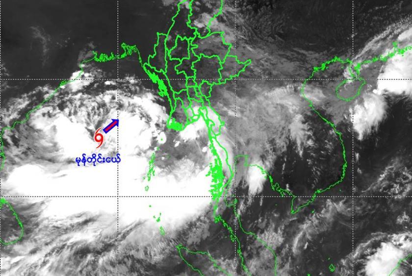
According to the announcement, the well-marked low pressure area, which is developing in the central western Bay of Bengal and adjoining southern Bay of Bengal, has moved to the northeast and intensify and has reached a depression in the central Bay of Bengal. The depression is centering about 300 nautical miles north-northwest of Coco Island, about 360 nautical miles west-southwest of Hainggyigyun, about 395 nautical miles west-southwest of Gwa, about 400 nautical miles south-southwest of Thandwe, about 410 nautical miles south-southwest of Khepupara, Bangladesh and about 425 nautical miles south of Canning, West Bengal State, India.
The current condition of the depression is set to yellow level as there is no condition to move towards Myanmar. The depression is located at 15 degrees north latitude and 88.4 degrees east longitude at 9:30 am, with a central pressure of 996 hPa and maximum wind speed of 30 miles per hour.
The DMH predicts that the depression may initially move northeastward and intensify, and may become a cyclonic storm in the east of the Bay of Bengal on the morning of May 25. Through this, it can continue to move northward and strengthen into a severe cyclonic storm on the morning of May 26. In the early morning of May 27, it may landfall between Khepupara, Bangladesh and its adjoining Sagar Island, Coast of West Bengal, India.
Due to the speed of the storm, rain or thundershowers will be fairly widespread to widespread in Nay Pyi Taw, Sagaing, Mandalay, Magway, Bago, Yangon, Ayeyawady and Tanintharyi regions, and Kachin, Chin, Rakhine, Kayin and Mon states between May 24 and 27.
Similarly, there will be occasional strong winds and big waves in Gulf of Martaban, along the coast of Mon-Taninthari and in the offshore sea. Surface winds may reach 40 to 45 mph between May 24 and 25, with wave heights of about 9 to 12 feet. There will be frequent strong winds in Delta areas, along the Rakhine coast and in the offshore sea, and the waves will be very large. Surface winds will reach 40 to 45 mph with wave heights of about 9 to 13 feet on May 24 and 50 to 60 miles per hour with wave heights of about 13 to 16 feet between May 25 and May 26.
Due to the speed of the storm, the weather phenomena such as strong winds, flash floods and landslides accompanied with heavy rains may occur and people who live near the highlands are at risk of landslides and people who live near the streams and rivers are at risk of floods. In order to be aware of weather phenomena in advance, domestic flights, long-distance fishing vessels and ships along the coast of Myanmar and in the offshore seas, can also be aware of the dangers, the DMH warned.