

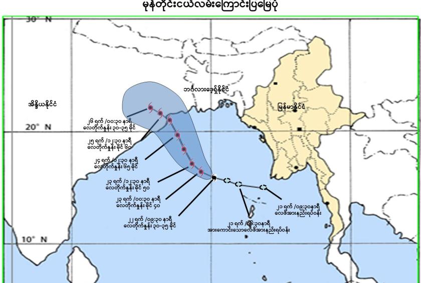
The Department of Meteorology and Hydrology has announced that the low-pressure area has intensified into a depression but will not enter Myanmar, marking it as a yellow-level alert.
As of 9:30 AM on October 22, according to observations, the strong low-pressure area forming over the central-eastern part of the Bay of Bengal has moved west-northwest and intensified into a depression. It is currently centered about 185 nautical miles southwest of Haing Gyi Island, Myanmar, and about 410 nautical miles southeast of Sagar Island, West Bengal, India. The current situation indicates that it is not expected to move towards Myanmar, hence the yellow alert level.
The depression is likely to continue moving west-northwest and could further intensify into a cyclone by October 23 or a strong cyclone by October 24 over the northwestern part of the Bay of Bengal. It may then move further northwest and cross the coast between Puri and Sagar Island in the early morning of October 25, possibly impacting the northern part of Odisha and West Bengal.
Due to the depression’s influence, there may be widespread rainfall across Nay Pyi Taw, Sagaing Region, Mandalay Region, Magway Region, Bago Region, Yangon Region, Ayeyawady Region, Taninthayi Region, Chin State, Rakhine State, Kayin State, and Mon State on October 24. In some areas, heavy rainfall and strong winds may occur.
The Department also warns that severe weather conditions such as heavy rain, strong winds, thunderstorms, lightning strikes, hail, flash floods, and landslides could occur. People living near hillsides should be cautious of landslides, while those near rivers and streams should prepare for possible flooding. The Department also advises caution for domestic water and air transport during this period.