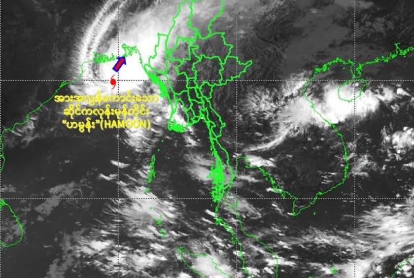
The Department of Meterology and Hydrology (DMH) released an announcement this afternoon that the severe cyclonic storm “Hamoon” over West-central Bay of Bengal may center at the Chin State and northern Rakhine State and dwellers from two states can suffer from the effect of cyclonic storm HAMOON.
According to the observation of DMH, the Cyclonic storm “ Hamoon” over West central Bay of Bengal has moved Northeastwards and it intensified into the very severe cyclonic storm “ Hamoon”. It is centered at about (290) Nautical miles West-Northwest of Thandwe, (190) Nautical miles West of Sittwe, (170) Nautical miles West-Southwest of Maungdaw (Myanmar), (160) Nautical miles Southeast of Paradip in India, (150) Nautical miles South-Southeast of Digha (India), (125) Nautical miles South-Southwest of Khepupara (Bangladesh) and (190) Nautical miles Southwest of Chittagong.
The DMH forecasted that it likely to weaken gradually while moving northeastwards and cross Bangladesh coast between Khepupara and Chittagong within 36 hours as a cyclonic storm with wind speed of 75-80kmph.
Rain or thundershowers will be isolated in Kayin, Mon States, scattered in Bago, Yangon , Ayeyarwady, Taninthayi Regions and Kayah State, fairly widespread in Naypyitaw, Magway Region and widespread in the remaining Regions and States with isolated heavy falls in Sagaing, Mandalay, Magway Regions and Chin, Rakhine States. Degree of certainty is (100%) within next two days.
Squall with moderate to rough seas are likely at times in Deltaic, off and along Rakhine Coasts. Surface wind speed in squall may reach (40-45) mph. Sea will be slight to moderate elsewhere in Myanmar waters. Wave height will be about (9-12) feet in Deltaic, off and along Rakhine Coast.
Under the influence of the severe cyclonic storm and vigorous monsoon, people should be awarded of strong wind, heavy rain, flash flood and landslide in the hilly areas and near small rivers and also domestic flight, trawlers, vessels and ships off and along Myanmar Coasts.