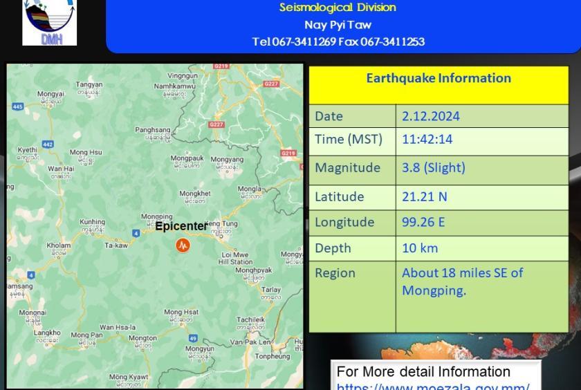
A minor earthquake with a magnitude of 3.8 on the Richter scale struck near Mongping on December 2, according to the Department of Meteorology and Hydrology (DMH).
The earthquake, centered about 18 miles southeast of Mongping and 21 miles southwest of the Kengtung Seismic Station at a depth of 10 kilometers, occurred at approximately 11:42 a.m.
Similarly, on December 1 at around 2:27 p.m., another earthquake with a magnitude of 4.9 struck 90 miles south-southwest of the Taungoo Seismic Station. It was centered within Myanmar, approximately 4 miles west-northwest of Kyankhin, at a depth of 50 kilometers.
On November 29, at around 11:32 a.m., an earthquake of magnitude 3.5 occurred. It was centered 14 miles west-southwest of Lewe, 22 miles southwest of the Naypyidaw Seismic Station, at a depth of 24 kilometers.
Earlier, on November 26 at approximately 2:33 p.m., a 4.9-magnitude earthquake struck 113 miles south of the Myitkyina Seismic Station. The epicenter was located 27 miles west of Mohnhin at a depth of 27 kilometers.
On November 20 in the late afternoon, a 4.5-magnitude earthquake occurred 42 miles south of the Kawthaung Seismic Station, centered near Kyauklet, 3 miles west of the town, at a depth of 10 kilometers.
Regarding the earthquake near Kyauklet, a resident of Phapon recounted: "While sitting, I suddenly felt the earthquake. My wardrobe shook noticeably, and I noticed the water in a jar rippling. However, it didn’t last long—less than a minute, just a brief tremor," they said.
The DMH continues to monitor and report seismic activities across the country.